None of the brochures show Kakadu in the "dry" season. This is because a lot of places aren't "lush & green". Instead there's many thousands of hectares of land that's been burnt to prevent wild bush fires that destroy every thing in it's path when the thunderstorms start in summer. The control burns still wreck some of the trees & shrubs, but apparently it all is lush again during the monsoonal rains. Areas that haven't been burnt, have tall dry grasses or green areas where the water is still drying up after the long & really wet summer.
Our 1st place to visit is Gunlom Falls. About 30kms of off road with the van again & stay the night in the campground 100mtrs from the beautiful falls & it's turquoise pool.
Rod went to the top of the falls & I took the track to visit a lagoon looking for birds. Rod took the camera & got some great shots of the many swim pools @ the top of the falls.
There were several pools & more smaller water falls up there. The people in pic above are just in front of the drop of the larger fall of Gunlom.
The next day we headed to a campground not far from the Yellow Water Cruise @ Cooinda. We booked a sunrise cruise for the next day as it's supposed to be the best for the birds. Many of the other walks in the area are still closed due to "seasonal conditions" - prob means either road is boggy or there's crocs still in the area.
It was a very chilly start to the day getting up @ 0545 to be at the pick up bus by 0620. Cruise started @ 0645.
We were treated with a beautiful sunrise over the Yellow Water lagoon & Sth Alligator river.
Thousands of Plumed whistling ducks every where.
Mapgie Geese taking flight to the new day.
This lone Jabiru was in the distance, as there is a haze when zoomed in for pic.
My sunrise pics are different to the bright green pics seen in the brochures also.
The 2hr cruise meandered around the huge lagoon & into & out of the river stream.
There was another boat with us to allow room on each for us to move around to take pics.
The Lotus plants weren't yet in flower
We spotted many crocs sunning them selves & lots of birds!!! The guide was helpful in telling us what they were to save me writing down the details of each species to look up in the book later :))
Magpie Geese build huge 2 - 3 mtr nests in the tree tops.
This pretty guy - girl actually is the forest kingfisher
Jim Jim falls also isn't far from another campground. The road is strictly 4WD country. (at least the last 10kms is) We had to engage 4WD on a single lane track, crossing several sandy patches & many many shallow water pools along the way. Ooh what fun.
Driving the last 10kms was also a treat as we got closer to the gorge area with high escarpments. (Rod didn't get much of a chance to look at the views though whilst concentrating in the job at hand.
On the way out I had to be spotter for oncoming cars coming from around blind corners etc. There were only a few areas to pull off the track to let oncoming vehicles pass.
There was quite a smoke haze when we got to the gorge. There was some wind to blow some of the smoke away, & many of my pics have smoke haze in them :(
This pic is taken at the beginning of the falls water hole. The falls are still 900 mtrs away - not far really!!!
Closer & closer we go, but it's taking an hr to get there.................
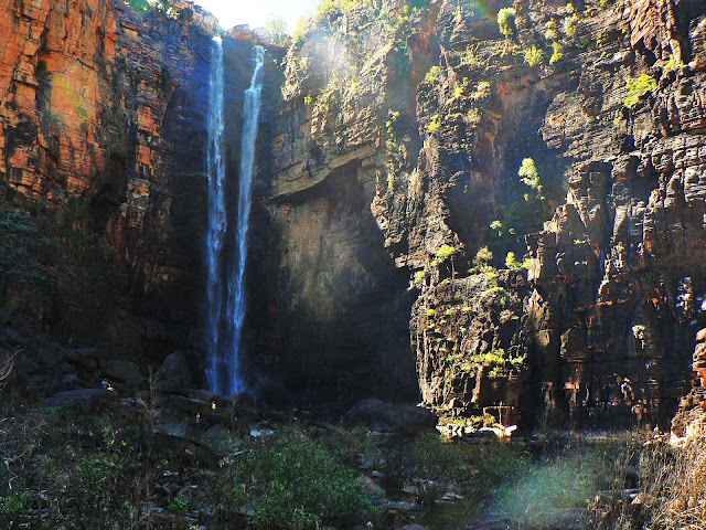
 Finally we are close enough to have to the falls if full view, no more rocks obstructing the full view. We felt the refreshing water spray on our faces. What a delightful spot. Unfortunately we were so close that the whole 150mtr drop of the falls top down to the pool below, wouldn't fit into the camera view. So that's why the 2 pics are split. :)
These are the spectacularly high cliffs surrounding us in the falls gorge. Rough, craggy rock.
This is an example why it tool us 1 hr to get up close to the falls. Very slow going, climbing, up, down, over huge bolders, some not so big, but slow going. Just as well we had markers to follow, or it would have taken twice as long, as some bolders are just too massive to get over. The caretaker at our campground said that at least 2 people are helicoptered out of the gorge due to broken ankles 'cos they wore thongs instead of decent walking shoes. Huh......stupid.
This cage is a croc catcher. There are signs everywhere warning of salt water crocs in the area & not to swim in the lagoon / water holes. We think there was a 'freshie' in this hole as the place was at least open to tourists. "Freshies' have too small a mouth to eat people.
Love to show you 1 last pic of Jim Jim falls - it's almost identical to the 1st - with 1 difference - we had lunch in this spot after the 2hr return difficult trek. Great spot to relax for just a little while.
The next day we went to Nourlangie - a place where the aboriginals spent a lot of time in in the several caves / rock overhangs during the wet season. This area is famous for the 20,000yr old rock art in at least 4 areas. Each area is a different type of era & subject of their art form. They would paint themselves in dance, the animals or plants they hunted for & ate, or the spirits - some evil.
This for example - above- is Nabulwinjbulwinj - Nar-bull-win-bull-win - a dangerous spirit who eats females after striking them with a yam
The funny creature on the right of the above pic is Namarrgon - the lightening man.
The full rock art section - women in costumes in dance on the lower section.
The Nourlangie rock escarpment was also spectacular.
I showed you the lightening man Namarrgon in art form - in the distance the Arnhem escarpment could be seen another 50kms away. There was too much smoke haze to get a nice pic, but this is what it would look like. Read the writing on the left of the plaque pic. Interesting.
We will be seeing more rock art again when we get nearer to Arnhem Land ,but still in Kakadu.
Apparently different rock art again.
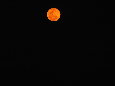
With all the control burning in Kakadu, I have some some amazing pics here - this moon is the night after 'full moon' night.
The sun setting this afternoon near Jabiru, behind smokey skies with a little high cloud, was also pretty.
We had to go on another 4WD track to get to this lagoon below. Not much bird life here, but a fisherman was just loading his dingy onto the top of his camper trailer. He said he experienced a rather major hit from under the boat whilst out on that lagoon - & it wasn't a submerged tree !!!!!!!!!!!!!!!
I love the picture of water lillies!!!!!!!!!!!!
These 3 pics were taken at a bird hide 30kms from Jabiru where we are tonight.
A magpie goose parent & 2 of his chicks feeding close to the bird hide.
Green Pygmy Geese also close by
A red combed Jacana & chick - almost on a lotus pad. These little birds have huge feet for it's body size - their other name up here in Kakadu is "the Jesus bird" - as it walks on water!!!
As I write this tonight in Jabiru, I can hear the patter of feet outside our van door & howling every now & then, form a short distance.
Most certainly not from the domestic variety ................
rather from 1 of these guys I photographed from next to the hwy, lying in the shade of a power pole
We've heard them a few times this past 4 wks & this is 1 of our last few nights in Kakadu -
this is also our 1st sighting on a dingo. He looks pretty relaxed there!!!
Am bloody pleased we have a loo in the van for our nighttime bladder relief!!!!!!!!!!!
Jabiru is just a small town with 1 expensive supermarket, 1 servo, 1 newsagent, 1 travel agent, 1 health centre, 1 cafe, 1 sport club with a license to sell alcohol, 1 caravan park & 1 resort.
There's 1 small airport near 1 probably large Uranium mine. Oh, & there's 1 hairdresser if you want a haircut.
There's no pub as it's considered a dry town.
We were issued with 'alcohol passes' to buy drinks @ the bar near the pool when watching the 'friday night movie'. Oh - guess what movie was being shown -
The Gall Boys - 'Crossing the Canning Stock route' hahahahaha - this is a movie produced on the Kedron boys on their adventures to different parts of the country. As most of you will know - we have a Kedron van & were given all 5 DVD's compliments of Kedron & the Gall Boys.
After Jabilu, we went towards the border of Kakadu & Arnhem Land - locality called Ubirr. No town, like most of Kakadu (except Jabiru). There's a "border store" for tourists to buy a decent coffee, buy take away food or book tours for the East Alligator river cruise or go over to Arnhem land tours.
Ubirr is 1 of those must do stops in Kakadu where there's more significant rock art & a climb to a look out rock looking over Nadab floodplains.
The rock art is a similar age to Nourlangie - over 6,000 yrs old at least. This area was very popular due to the significant water supplies & wild life surrounding same. The East Alligator floodplain region is huge towards the coastal areas. Many caves @ Ubirr has rock art.
A lot of art work of different species of fish
2 of the caves with rock art - the 1 above had a 4 metre freize
The Rainbow Serpent is considered bad
Interesting interpretation -don't think I did any thing bad to get the nobly bones on my fingers - wonder if my other joints will go the same way?
This common butterfly was resting next to the Rainbow Serpent.
We passed the caves to climb a rather large rock to view the Nadab floodplains. The views were magnificent. You could see uninterrupted 360* views.
That's Arnhem Land in the disstance in both these pics.
To the left of the Arnhem Land escarpment is the massive floodplains of East Alligator River.
These floodplains are called Nadab. Not as many birds here as I thought - there was so much rain 2011 that the water birds are spread out all over the 'top end' - not just in Kakadu. Very pretty just the same.
Rod says - 'how good is this' !
We went back later the next evening to do the sunset views. The colours didn't disappoint us. The rock was swarming with people doing the same as us.
The rock to the left in above pic is the rock Mick - Crocodile Dundee stood on to tell Sue the American journo that this was 'his back yard'. Apparently the company was fined thousands of $$ for that as they were on a sacred rock.
We took a cultural cruise up East Alligator River. The aboriginal guides lives in the area. Besides going up the river, we were shown the different spears & each use. 1 not for food collection!
The cruise up East Alligator river was pretty. Going up stream, Kakadu was on our right & Arnhem Land to our left.
These trees will never regrow after the destruction from a cyclone that went through the area a few yrs ago.
This rock has 2 faces
The river is popular for barra fishing as well - locals & many tourists tow their boats from all over the country to fish in the Top End.
The escaarpment of Arnhem Land was pretty rugged.
We also saw a few crocs sunning themselves as well.
There's a 2 - 3 yr old hiding behind the bushes.
On the river bank were a couple of Black Wallabies. Short, thick & mean looking - check out his biceps
The rocks & escarpments around are many yrs old - 1.6 billion yrs old in fact. The sandstone in the next pic are being eroded away a rate of 1 mtr every 100 yrs - I think??
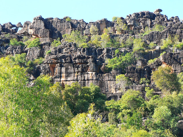
There's many of these 'layered looking' formations in a lot of places in Kakadu, but many of them are around Ubirr. Walked around a few like this 1 on a morning walk. Fascinating.
I such rocky outcrop is called Jabiru Dreaming. Apparently Jabiru like to perch on these high places to check out whats going on down below.
I thought they were statues on the rock, until I focused my binoculars on them, to find them moving a little.
Another fascinating feature @ Ubirr is Cahill's Crossing. It is a causeway over East Alligator river. Non Arnhem Land inhabitants need a special permit to go over to the other side - even to fish @ the crossing.
Many people go to the crossing area to fish for Barra - the most popular time is high tide. Fascinating just to be a spectator as well. You wait for the tide to reach it's high mark - the waters are still for a few minutes & then it starts moving out again. had to be seen to be believed.
As we waited for the high tide, Rod tried a bit of Barra fishing as well on the rocks where the barra are more concentrated. Unfortunately we didn't have fish for tea the night. He caught 2 - under the required 55cms length.
There many men fishing close to the water- in the water some of them. 1 wonders why they take risks as many crocs are lurking around the crossing each high tide waiting for the barra just to rush in to their wide open mouths.
That is no small croc!!
This 1 had crossed the causeway a while earlier to catch the fish coming up stream with the incoming tide. Once the tide turned he took him self down stream again..........I wouldn't be fishing any where near that water!!! Apparently there are many tourists who don't even see the many croc signs everywhere & wade into river & lagoons. Salties also inhabit fresh water. I'm too scared to swim any where!!!!!!!!!!!!!
Just to show his small catch - at least he had a go. I'd have just gone to the fish shop :)
I mentioned @ the beginning that Kakadu has always been controlled burnt - either by the inhabitants 20,000 yrs ago or by National parks of Kakadu. We always came across burnt out areas. Came across this on our 2nd last day in Kakadu - the hawks & kites were having a field day nearby, waiting for rodents & insects to rush away from the hot flames
Most of the plants are fire tolerant unless it's a 'hot' fire that is left too late in the season. Most things grow lush again when the monsoon rains start again next wet season.
That's it - 7 days in Kakadu. Would love to return when it's lush & green during / after the wet season. Many areas were still in accessible due to the area having water over the tracks. We missed out on many lagoon walks due to the late rains.


