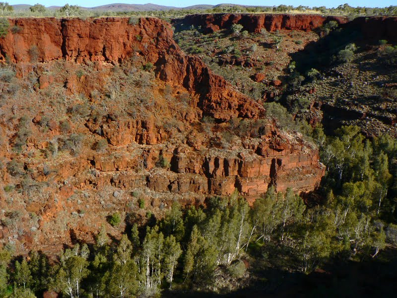
Karijini National Park is the 2nd largest such park in WA @ 627,000 hectares. It is part of the Hamersley Range which started to form 2,500 million yrs ago as sediment on the sea floor. Over millions of yrs the iron-rich deposits were transformed by more complicated geology that I won't bore you with. Geography lesson is now over :) The mining companies are taking over nearly every profitable parcel of land & turning it into deep pits. Thank goodness for National Parks.
Mountains & escarpments rise out of the flat valleys. The area has breathtaking gorges (that go 100 mtrs into the earth rather than upwards) & stony, tree lined watercourses. Snappy Gums - the white gums in the pics - look stunning against the rich red escarpments. Almost the entire area that is accessible to the public is covered in seasonal wildflowers, spinifex grass that is still green, snappy gums, eucalypts, mulga trees & many more native bushes.
Erosion has created the landscape of rolling hills, escarpments & at least 6 gorges over 2,000 million yrs.
Driving through the eastern approach road to Karijini gave us amazing views of scenes to come
The road was created by blasting through the mountain to give better access from Newman to Port Headland.
The views from a lookout are amazing.
Every where we drove we had amazing views like these
These 2 pics above were also our back door view
Dales Gorge is the closest to our camp ground. You can see how the wide gap opens up into earth from the landscape. We had magnificent views for our 1st taste of Karijini gorges.
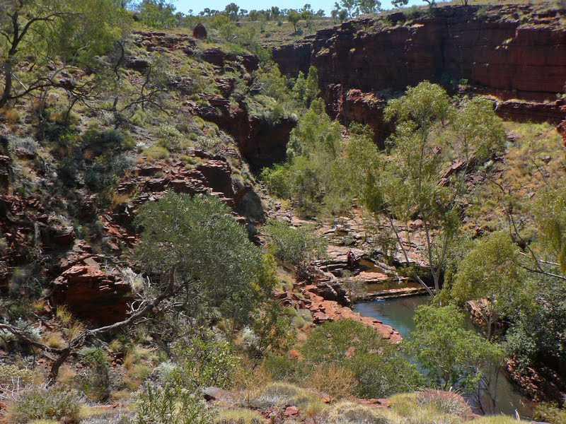
Fortescue Falls is at 1 end of Dales Gorge & Circular Pool around to another end. We went down 100 mtrs to the bottom of the gorge for a 1 hr walk from Fortescue to Circular Pool.
This is the rocky edges we had to navigate down - made by nature :) Some ledges were slippery.
Near Fortescue Falls is Fern Pool - the water was really chilly according to Rod, who tries out every watering spot on our trip so far.
A fig clings to the rocks in a damp area with what looks like maiden hair fern growing.
Like a cake, layers of rock is constantly seen
Looking downstream from Fortescue Falls.
Amazing colours in some rock pieces lying around
If you look closely in the above pic, you can see a pillar that looks like it's supporting the side of the cliff face.
This Snappy gum tree clings to the edge of the gorge.
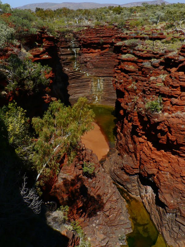
We're approaching Circular Pool now - this area is really wet, with water seeping through the rocks creating a fern garden. The area looked really pretty.
Now we're in Circular Pool. Looks like a big circle. It has a water fall during the wet season, so the water is now seeping through the rock like an aqua filter. The colours of red rock & green fern was dramatic.
Walking back out again to near the fern garden area.
Reflections of the sky in a smaller pool further out where there's more openness.
Climbing up the 100 mtrs again, showed some amazing views ....... again. Besides I was taking pics, not catching my breath!!!!!!!
Back on top of the gorge & walking back the 1 km along the rim of the gorge. Snappy gums are against the back drop of red.
From a lookout, this is what Circular Pool looks like looking down.
Dales Gorge from the lookout looking towards another gorge.
Weano Gorge was a 45 min drive away. (the other 4 gorges are near by as well)
This is the view from the top before going down 75 mtrs
Some sections of the gorge walk are class 5 out of 6 (6 needing a guide). I was slightly challenged in a couple of sections. We had to take our shoes off & get our feet wet ( we had reef walker shoes for comfort).
Just behind the lady in pink there's a self guided ledge made of rock from the cliff face. This is where we walked some of the way to avoid getting wet up to our wastes.
At the end of Weano gorge is Handrail pool - there were some difficult & narrow slippery sections we walked through before coming down the handrail.. You can see we had some climbing down & up to do via the handrail. !!!! There wasn't much to do here, except maybe have lunch or a snack before going back the way we came.
Oxer lookout was nearby.
It is a junction where 4 gorges meet. Can't describe each 1, but Weano was 1 of them.
Weano Gorge
Hancock Gorge
You can see the pool of Hancock gorge from the pic below. It's a long way down there!
They all start to look the same after a while...........
We had to go down another 100 mtrs again to get to Hancock Gorge. This walk is a class 5 again in sections. Definitely took me past my comfort zone. We had to hug the wall of the cliff, walking on narrow ledges again to keep out of the water. Yhis is the section we left our backpack & shoes behind again, along with my binoculars & camera. Just hoped every one was trust worthy there. for most of the following pics I used the video camera that can take stills as well. (it is an under water camera)
This area of the 1 hr walk was the easy part :)
This is the section where we left our gear behind. We had to find our own path above the water line.
Some of the pics are over exposed as you can't adjust exposure.
Looking upwards on the way out again
The next day we returned down the same road & diverted towards another pair of gorges - Knox & Joffre Gorge. Same, same but different .............. day.
These pics are looking down into Knox gorge. We only had enough time to do 1 of the 2, so Knox got a cross, for no particular reason other than Joffre has falls. Oh & that Knox takes 3 hrs return & Joffre only 2 hrs return. Why not make life easier on ourselves.
Joffre Gorge has a lookout.............both to the left up the gorge looking towards the falls
the water flow is just small now, with the water & pool looking quite green at the end of August
This is looking downstream towards the other gorges (even though the others are a few hundred metres away.
On our way down to the bottom of the gorge we found some friendly looking spinifex pigeons.
We passed some smaller water falls at the top.
A small pool before the large drop to the bottom.
This lizard stayed still enough for me to get a pic before it disappeared under the clumps of grass.
Getting down to the bottom was another class 5 walk. Unfortunately the difficulty got the better of our safety & we stopped about 2/3 the way down............ probably about where you can see the smaller clump of fig under the much larger patch of fig tree on the right. The walk was marked, but there were no safety rails again & the drops to each next rock level became bigger, giving us an uneasy feeling going down...........1 slip & you're down to the bottom in a flash in a crumpled heap.
Karijini has the most accidents of any other National Park in WA, & we can see why from the walks we did.
Evening sets on our final day there & the views are quite pretty.
Last, & not the least few pics of some of the wildflowers that make Karijini look more spectacular than usual.
I wonder why most of the flower colours are white,mauve & yellow. The looked gorgeous & yet dramatic against the green spinifex, red ground & gorges & snappy gum trees around the hilly landscape.
Karijini gets my vote as being the most scenic area we've seen so far on our trip. I couldn't find another place so special to spend my 55th birthday. We had a most enjoyable time during our 4 day visit there.


No comments:
Post a Comment