I purchased a specialised map book for this road. It gives heaps of details such as the road house for fuel, every Bore, GPS co-ords, places of interest to stop for a look. It shows the minor roads to properties, places to camp, lakes, river & creek crossings & so much more. There's detailed distances between each point of interest & some photos. Basically it's the Birdsville Track travellers bible & a must have.
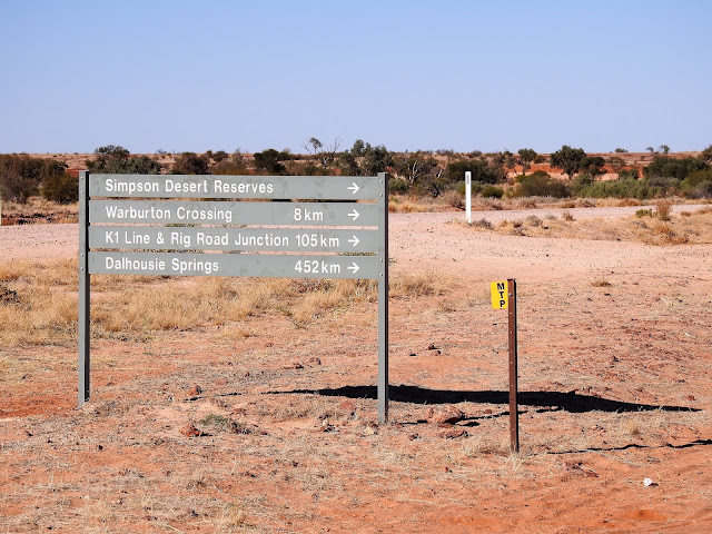
The road sign says it all for the type of road we are about to drive on.
We had already travelled from Windorah & were heading towards Marree.
As we drove south, we encountered several dozen vehicles that were travelling north to Birdsville for the Birdsville Races to be held in a few days time.
Marree is at the bottom end of The Birdsville Track.
We turn our clocks back 30 mins. Thank goodness for that as we were living on Qld time that is excellent for the east coast & Brisbane was 1,600 kms to the east.....where the sun rises almost 1 hr earlier.
It didn't take us long to discover some of the hazards of the road. Those soft looking patches were deep bull dust holes. A powdery dust. Thankfully road maintenance gangs had placed flags at each side of the hazard to warn drivers of such hazards so we could drive around them.
We drive next to sand dunes that are covered in grasses & flowering Wattle bushes.
An old rusty car.....it's seen better days & probably came a cropper & flipped as the roof is crashed in. It's serves as a reality check to make sure that you're not driving too fast for the conditions of the road.
I like signs.
The Warburton Track. We weren't going that way. That road leads West into the Simpson Desert.
We stop at several places for me to do some birding. We don't need to rush this drive any way. I find my target bird the Grey Grasswren 91 kms south of Birdsville at lunch time, so I had a little happy dance.
Our little map book has camping spots in it too, so we stop for the night near a dry creek south of the southern entrance to the Inside Track.
What a sight for sore eyes. All that dry sandy country that we'd passed the previous day & here is this lush oasis...
Two Wells Dam......pretty sure it's a Bore & it's provided a little wetland for some birds & much needed drinking water for the cattle that were there.
Not mush further down the track we came across this small fenced off area. The sign explains it all.
That's the Mount Gason Wattle.
I couldn't imagine anything would be interested in eating those spiky leaves.
Mirra Mitta Creek crosses the Track. It's the 2nd lot of water we see & both in a few hours. It's a sight to behold. We stop here for a while for me to check out the bird life at this inland wetland.
To my amazement I find plenty of interesting birds.
The Creek is really being back filled by the Mirra Mitta Bore that is up stream of the creek.
That's the wetland downstream of the overflow pipe from the dam. It's a green oasis with plenty of birds there including a family of Brolgas. Cattle use the puddles or the dam for their drinking.
I walked upstream of the dam. I could see the steam coming off the water the further I walked.
It's difficult to see, but that clay looking stuff is algae. It was really interesting to look at & not normal looking algae.
The bore water has a lot of calcium in it, hence the white powder look on the bank.
The channel in which the water was flowing was quite wide in parts & spread out to form another wetland where I found a Spotted Crake foraging for food. No photo though.
That's the actual Mirra Mitta Bore. It's about 300m upstream of the dam. The sign says "Danger don't get close" as the water is near boiling point as it's coming from several hundred metres deep within the Great Artesian Basin.
You can see the steam coming off the water & the flow is quite considerable as seen from the pipe near the top centre of the photo.
We're now approaching the edge of the Sturt Stony Desert. Gibber country & my eyes have been looking out for Gibberbirds that love this type of country. Most of the country has been flat with sand dunes.
In front of us is a little range called Mungarannie Gap that is just north of Mungarannie.
30 mins later & we arrive at Mungarannie turnoff.
Mungarannie is a pub, camping ground, fuel station & most probably emergency vehicle repairs out the back in a work shop.
Mungarannie is the 1/2 way point on the Birdsville Track between Birdsville & Marree.
I love their outback humour as this is never going to happen. I'm also not sure if the bus stop actually is a real bus stop as there's only tour buses passing through.
I didn't see a working tow vehicle, but these 1's have seen better days.
Heading towards Birdsville races.
Walking around the camp ground & the sand dunes near there.
Many pioneers tried to start a life in this remote part of Australia. Many failed & homesteads were abandoned. In some instances the homestead was perhaps in the wrong area for better access to their large tracts of land.
Thus we came across many homestead ruins like this 1. Old Mulka Ruins, was a Homestead & Store established in 1924. It was the loneliest store on earth. Mulka is claimed to have the lowest annual rainfall in Australia = 18mm.
Cooper Creek runs beside the road for a short distance. We had a lunch stop here. The grounds were quite dry & dusty.
About 200m down the road we came across the monument for the barge that would cross the flooded Cooper Ck with passengers, supplies & mail in 1949.
Just before we pulled into this camp ground we pulled over to the left of the road to let a convoy of 4x4 vehicles pass us. It's sad to say that we ended up cutting a tyre on a sharp stone despite our tyre pressures being down & we were driving at a very low speed :-(
This is part of Clayton's Wetland campground. We spent an hour there changing the tyre.
Clayton Wetland & creek were completely dry.
There is a small spa for travellers to use if desired.....it's that small black tank in the photo....filled with bore water & empty when you're finished.
Further down the road we came across a mob of brumbies or they could be the station horses roaming for food.
We arrived at another station house ruins. This was at Lake Harry ruins & a free camp spot. We were by ourselves for the night.
The lake was completely dry, but I still enjoyed walking around looking for birdlife & other interesting things.
An unusual bush....the leaves were velvety & thick, protection in desert conditions.
The next day we arrived at Marree. This building is the lifeblood up / down the Birdsville Track where travellers get mechanical or tyre repairs. It is also a fuel station, souvenir & small grocery store. Lake Eyre flights can also be booked through them.
We had to replace the damaged car tyre from the previous day. But on checking around the caravan hubby noticed that 1 of the caravan tyres was showing some wire thread. We didn't despair over replacing this tyre as it is 1 of the original tyres on our 7 yr old van. All be it that the tyre replacement was a little more expensive in Marree than if we'd waited another 2 - 3 weeks to replace. We still had much more dirt road to travel yet before proper civilisation. That caravan tyre certainly has travelled several thousands of k's of road incl gravel roads too.
Whilst the tyres were being replaced, I walked around some of town to take in some of the history.
The Lake Eyre yacht club will have a slow season for a while as the lake was completely dry.
The Old Ghan railway line ran through Marree.
Tom Kruse was a mail contractor who drove the Birdsville Track from 1936 to 1957. He owned the business from 1947. He delivered mail & other supplies including general stores, fuel & medicine to remote stations from Marree to Birdsville. Each trip would take 2 weeks & Kruse regularly had to manage break-downs, flooded creeks & rivers & getting bogged in sand dunes.
A movie / documentary was made in 1954 in his honour "The Back of Beyond".
The Leyland Badger Kruse drove which was abandoned at Pandie Pandie Station in 1957 when it would go no further.
Beautiful lead light glass work above the door of the hotel.
A mural on the wall in the dining room.
An old wagon.
Leyland Badger stands on display near the Hotel.
We drive off the Birdsville Track & now onto The Outback Hwy.
Driving out our Marree.
Around Lyndhurst I obtained permission from the owners to stay on their private property so I could try & find some particular birds on my target list. It's very rocky / shale.
Interesting shale formations on a slope.
Some of the desert like plants growing in this dry area.
Sadly we sustained another tyre puncture on a relatively good gravel road just 20 kms south of Marree after we had just paid a lot of $$ to replace 2 tyres. It was the previously repaired tyre from south of Isisford in Qld & fortunately this hole could be plugged too.
But we got away lightly as we heard so many stories of people getting many more punctures along the Birdsville Track.
That's the end of the Birdsville Track. We survived the drive & it wasn't as daunting as expected. There were so many scenery changes, we took our time & our 516 km trip was broken up quite a lot as I searched for birds along the drive.
We stayed overnight in 3 places along the way.


No comments:
Post a Comment