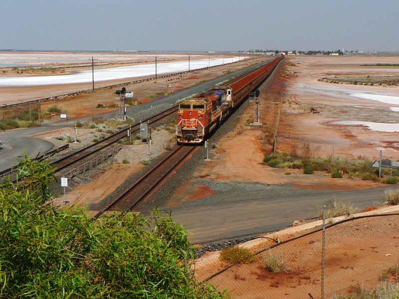
Port Headland is on the north of the Pilbara region. 600kms south west of Broome. The town was purpose built for export shipping as it has a natural deep anchorage port. In the 1960's iron ore was discovered in the area & Port Headland has become 1 of 2 major towns that export the ore. The town of 14,000 people is constantly on the move. Peak hour traffic starts as early as 0500 hrs as we can contest due to us being in a van park for 3 nights next to a main road. A pillow over my head in the morning to block out the noise wasn't effective. Live cattle are also shipped out of the port.
It is difficult to portray how massive the industry is, but taxes, royalties & rates revenue to the WA govt for the financial yr 2110 was $800 million & $1.8 Billion to the federal govt. That's for BHP Billiton only.
My guess is that Rio Tinto paid similar figures.
The North West Gas Venture which contributes $5 Billion in State & Commonwealth taxes & royalties each yr.
It's mind boggling!!
It's no wonder why the cost of housing in the Pilbara is outrageous with a 3 bedroom fibro / wooden house with 1 bathroom, 1 carport, no pool in the yard costing in the vicinity of $700,000. A house with 4 bedrooms & 2 bathrooms would be over $1.2 million. It's all relevant to the resource industry incomes & the demand on housing.
Over 200 million tonnes of iron ore was exported in 2010. BHP Billiton is the primary exporter from 1 of 2 ports in Port Headland. The ore is mined from 7 mines mostly around Newman, over 400 kms from Port Headland. Newman's Mount Whaleback mine is the largest open cut ore mine in the world @ 5 km long & 1.5 kms wide. Fortescue Metals & other smaller companies also exports iron ore from Port Headland.
Most ship loads of iron ore weighs approx 200,000 tonnes @ a cost of $30 million.
Ship capacity sizes vary.
A Korean ship, typical of the size of the ships taking iron ore back to their country. It takes 24 - 36 hrs to load 1 of these babies before it's ready to leave port. The load of ore is deposited into the bowels of the ship at a rate of 10,000 tonnes / hour. Insane figures & costs.
There are only a few beach areas in Port Headland & this is 1 of them at low tide. 1 km further on from this area, the sand dunes are the nesting sites during period from October to March for turtles.
Sadly we only saw ore trains 1/2 the size described above with 2 locomotives & 116 carriages of ore - still looks awesome when coming towards us standing on a bridge.
Each of these ore carriages carries 110 tonnes of iron ore.
We went on a 2 hr tour of BHP Billiton s port facilities. Some of the equipment in the area is massive.
This is called 'spaghetti junction' by the highly paid workers. The ore comes in by train, gets unloaded 3 carriages at a time without the carriage being disconnected from the train.
The ore is sent via conveyor to stock piles in grades according to size & purity of approx 200,000 tonnes.
Countries will request particular types ore, so a reclaimer will take the processed ore into it's huge buckets, transferred via a conveyor again to the ship, as seen below.
Salt is also exported from port Headland. Port Headland also has several hundreds of hectares of salt paddock between Port Headland & South Headland by Rio Tinto.
The salt is exported for industrial, manufacturing or used on the icy European roads.
Sea water is deposited into ponds where mother nature's hot sunshine evaporates the water, leaving dried salt. This process may take 12 months. After harvesting from the dry ponds, the salt is kept in a huge pile & then loaded onto trucks which then take the salt to the port to be loaded onto ships in a similar way as the ore.
Port Headland also had great sunsets :)
Because we're driving in the Pilbara region that is huge in mining iron ore, we encountered many over sized vehicles on the road.
We crawled at a pace of 60 km/hr for nearly 10 kms behind this monster as it takes up all the road. All oncoming traffic is sent to the verge of the road by pilot vehicles ahead of it.
Tom Price is right next Karijini National Park. Tom Price was built in the 1960's for the purpose of Iron Ore mining. Rio Tinto mines the ore at several mines from the Hamersley Range around Tom Price.
Mt Tom Price is a mountain that is now a hole in the ground.
We went on a tour of the RioTinto mine site near Tom Price.
This is 1 of the huge tonka toy :)
We were hoping to see a live mine operation, but shown the site that is no longer used for now.
The hole in the ground used to be a mountain the size as the hilly section seen behind the open pit. The pit is at least 100 mtrs deep, several hundred mtrs long & wide.
Due to very strict OH & S rules, we had to don a hard hat & goggles after getting out of the bus.
Cool hey!!!
Imagine digging your back yard up with 1 of these fellas.
I'm standing just a little in front of the baby.
Unfortunately not many of the big ore trucks passed near us.
On the way out the entry gate, a 4WD has been crushed as a demo of how easy small vehicles can't be seen from inside the larger mine vehicles.
Some spares!!
Another big shed.
There's red swans in that tank of water. Well they're made of metal. The water is used to spray done the dust from the ore.
That machine at top of pic is the rock ore crusher.
Another re claimer that loads the conveyor from a stock pile, that then eventually fills the wagons.
Mt Nameless is the highest mt in WA at a height of 1128 mtrs. It was the back drop to our van park. It also is 4WD access to the top for some great views.
This is the view from the back of the mountain before we started our low 4WD slow trip to the top.
On the way up we (mainly I as Rod was concentrating on the really rocky track) had some great views of the ruggedness of the my & surrounding valleys
At the top, the views over Tom Price were magnificent, though hazy. Panorama from left to right
Still on the panorama, the mine site isn't that far from town.
From a little lower done the mt. That's an active mine site.
Views of the our on the way down again.
Another view from the back of Mt Nameless at the bottom.
Beautiful things still grow on those mts. Fortunately Mt Nameless can't be mined :)
It's a weird flower & I have no idea what it is.
Karratha & Dampier are 200 kms further down the coast from Port Headland. These 2 towns are also run around industries of iron ore, salt & gas.
T
Rio Tinto runs the iron ore & salt industry with the ore coming >300kms by rail from Tom Price. Their trains are 3 locomotives pulling up to 244 ore carriages.
There is 10,000 hectares of land for salt production. The colours at different stages of evaporation is pretty
This is the 4 ship berth facility for loading ore @ Dampier - just across the road from our van park. We sit in the late arvo having drinks watching ships being moved in & out of their wharf berth.
The salt loading facility is at another wharf in Dampier.
The North West Shelf Gas Facility is about 125 kms off the coast of Dampier with depths of 125 - 131 mtrs. The gas comes to the main land via large 1 mtr wide pipes for processing before it is loaded onto purpose built ships for exportation to Japan & China. A pipe also takes gas to Perth & Bunbury. Visiting the information centre was fascinating.
More expansion for the Pluto project - more facilities for gas processing.
I took this pic from a brochure to show the purpose built ships.
There were many more pics, facts & figures that could be given, but my head is glazed now & I guess yours is as well.
I hope you enjoyed the read & got some gist of how big the industry is in The Pilbara.
Also just how much revenue the WA & Commonwealth govts take from this area.