Due to shallow waters along the coast, the long jetty was built to allow sailing ships to be loaded with grain from the surrounding districts. The jetty was extended in 1883 to 1680 m.
It was later reduced to 1532m following the reduction of the port.
The lighthouse was erected at the end of the jetty in 1894, replacing the Port Germein Lightship.
The lighthouse was moved to it's current site in 1975.

Telowie Gorge Conservation Park was just a few kms SE of Port Germein. This 19 square km gorge is part of the southern Flinders Range NP. It is home to the Yellow-footed Rock wallaby.

After a busy 2 nights stay at the very popular Moonta Bay, (it was school holidays ) we headed to the 94 square km Innes National Park at the lower end of the Yorke Peninsula. Much of the area is exposed to prevailing southern ocean winds & much of the plant life in the NP is heath.
Innes NP was proclaimed in 1970 to protect the Western Whipbird, Malleefowl & the heritage buildings at Inneston. There are over 330 species of native plants in the NP.

We were tucked in next to a sand dune near Pondalowie Bay & were mostly protected from the southerly windy conditions.

Driving everywhere to the sites in Innes NP, we were greeted with spectacular scenery & rugged coastline. AS we drove around we noticed not only exposed rocks shores, but dozens of hidden rock islands & shelves. We have been stunned by the number of lighthouses along the SA coastline. Many of the lighthouses were placed after a shipwreck.
There are at least 4 shipwrecks located within the national park or adjoining it's coastal boundary.
SS Marion, Ethel, SS Ferret & un named vessel.
This is Roysten Headland.

Wildflowers on the walk to West Cape

Some of West Cape area.

Billboard of the above photo.

West Cape Lighthouse.

Ethel Beach is the site of the shipwreck Ethel which ran aground in 1904.
SS Ferret also ran aground here in 1920.


What's left of Ethel or SS Ferret shipwreck.

Chinamans Hat Island is the site of the shipwreck SS Marion which ran aground east of the Island during 1862.

Inneston Ruins have mostly been renovated & some of the buildings are now accommodation houses.
European colonisation of the area began in 1846 with sheep grazing near Cape Spencer. Crops were grown in the 19th & early 20th century. Commercial quantities of gypsum was mined in the early 1900's at Inneston in 1913. Gypsum was mined until 1930 when the Great Depression made it uneconomical. Some gypsum mining still continues at Marion Bay, just outside the NP.

Cape Spencer Lighthouse.

More views from Cape Spencer Lighthouse.

Cable Bay is between Cape Spencer & Chinamans Hat Island. There's a campground near here but is quite exposed.

Stenhouse Bay was our last "tourist hotspot" for Innes NP. Stenhouse Bay was named after the pioneer of the Gypsum Company he owned. Gpsum was mined at Inneston & transported by rail to Stenhouse Bay to be shipped for national usage.

The jetty was the only way to get the gypsum from train to ship.

This info board states that 26 shipwrecks are dotted around the coastline of Yorke Peninsula.
Another lighthouse can be found at Stenhouse Bay.
Hougomont was scuttled in 1832 to form a breakwater lies close to the coastline somewhere near Stenhouse Bay.

Stenhouse Bay.


We moved closer to Adelaide for me to visit wetlands on the northern outskirts at Magazine Road, Salisbury.
We also visited areas around St Kilda, Port Gawler, Middle Beach for shore birds arriving back to Australia from their breeding grounds of Mongolia, Russia & Arctic Tundra.
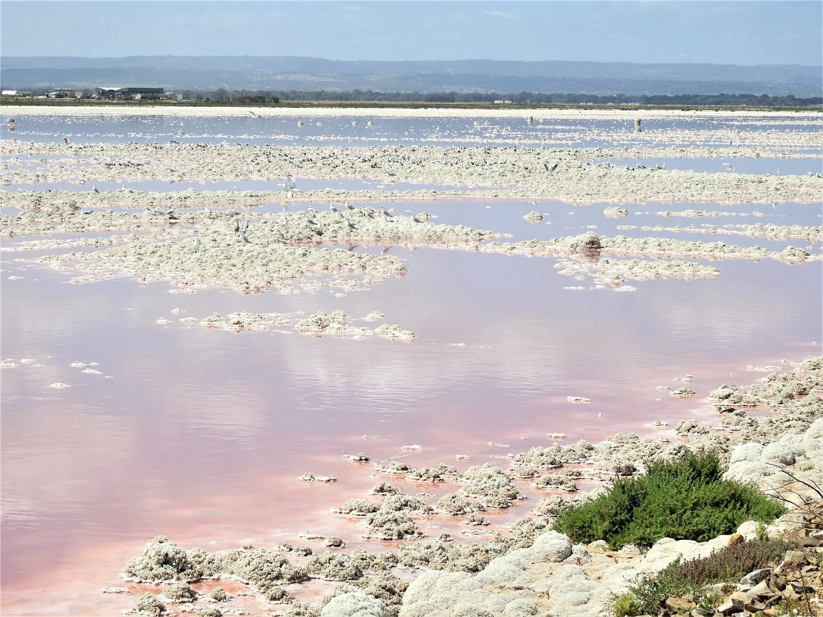
This is a salt lake at St Kilda. There are very few birds that will inhabit the extreme saline conditions of these salt lakes, apart from Banded Avocets, of which I saw a couple dozen there.

The salt is mined.
We moved again & stayed a night at Williamstown & then 3 nights with friends at Springton & also visit the Barossa & Eden Valleys.
This is the water storage lake of Barossa Reservoir built 1899 to 1903. The wall is Whispering...true phenomena. 2 people can stand at opposite ends of the wall & speak with each other despite them being about 100 m apart.

On 1 of my walks in reserves near Williamstown I found orchids growing.
Wax Lips Orchid.

Spider Orchid.

Pink Sun Orchid.

We also walked the street of Williamstown to see the beautiful old buildings.


Our friends live in Springton & we were able to park our caravan in their expansive yard.
On the edge of their town was this huge old tree - it must have been this size & hollow in 1855 for a family to live there for 5 years.


We spent at least 2 days driving the districts of the Barossa & Eden Valley visiting many wineries.
Both hubby & I had wine tastings after visiting numerous wineries.


It's a very old wine cask.


Those grape trees are 1 of the oldest in Australia.

That's 1 grape vine extending all the way along the wall.

We also visited Maggie Bear's property & cafe & had fun in her commercial kitchen with a display cooking session.


Many of the wineries have rather classy entrance gates & seem to try to out do each other.


Our next few days stay was driving to Waikerie on the Murray river & another 50 kms north to a property owned by Birdlife Australia.
The 540 Square Km property was purchased to preserve it's several plant habitats & several birds endemic to the region.
There are 3 camping areas & once checked in we were given a map for me to know which roads to drive to reach certain birding habitats. GluePot is very popular amongst the birding community with over 200 species been seen there.
Along my meanderings to locate birds, I came across more lizards.


1 morning I even found fresh animal tracks crossing the sandy track....perhaps a goanna.

Then there was a snake track.

We used the free punt to cross the Murray River back to Waikerie. We only had to wait a couple of minutes to drive on & less than 5 minutes we are on the other side.

We stayed at a caravan park a little further upstream at Kingston on Murray.
These were the views a short 200 m walk from our caravan.

Banrock station is not only a winery, but an expansive wetland. The 1,375 ha Ramsar 2002 listed wetland comprises of several lagoons. The wetlands on the property had been permanently flooded since the early 20th century. In 1992 a program began to restore the natural hydrological events of flooding & drying cycles. It not only supports over 180 bird species, but threatened animals also call the wetlands home.
Banrock Station also has hundreds of hectares of vineyards. All the vineyard profits are re-invested to fund environmental projects around the world.


The walking tracks around the wetland was 8kms on a good gravel track.


Flood levels of the Murray River & these wetlands.

We had just 2.5 hrs to walk the 8 km track to return in time for lunch. (as a birder, that's a fast pace)
It was a busy 8 kms as I tried to spot the birds there, take photos & record the birds onto my phone birding app.
My head was down inputting data when hubby stopped me just 1 m short of stepping on this deadly Brown snake that wasn't interested in moving. Oh dear, it was hot weather & I was wearing shorts too.


We arrived back in time for a very tasty lunch & a glass of wine overlooking the beautiful wetlands.


We also visited Hahndorf again. Our last visit there was in 2011. We loved the atmosphere & old buildings. Hahndorf is all things nic nac & some of it of German origin.


We visited a German pub for lunch.

Hubby had a tasting of beer plus a gourmet hamburger & my meal was the Goulash below.


It had rained an hour earlier.


We travelled further south & headed towards the Fleurieu Peninsula, staying at several communities to explore the area.
We even had flowers near our caravan when staying at Mt Compass.
These are Proteas


We were surrounded by great bushes at our camp spot in Mt Compass.

Just up the road from our camp ground was a farm with dozens of donkey's.
Unfortunately the males were quite vocal day & night.

I had to take a pic of the unusual cloud formations later in the day that was hanging low over us.

These are the Ingalalla Falls.

We stayed o/n at Normanville too on our way to Port Jervis for our ferry ride over to Kangaroo Island.

Next up is Kangaroo Island on this wonderful tour of South Australia.
No comments:
Post a Comment